Edjudina Gold Project
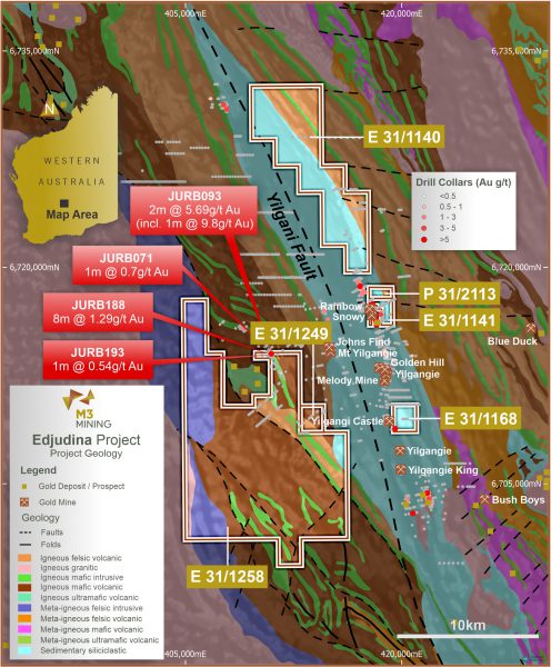
The Edjudina Project comprises six licences held (E31/1140, E31/1141, E31/1168, E31/1249 and P31/2113) or under application (E31/1258) by the Company which are located approximately 150 km north east of the regional city of Kalgoorlie in Western Australia. The Project can be accessed via excellent quality tarred and gravel roads while the tenement areas are readily accessible by gravel and station access roads. The local roads, while requiring upgrade to support any mining operations, are currently accessible all year-round and suitable for access by exploration teams and associated equipment including drill rigs.
No large-scale mining has occurred within the tenement area, however historical near surface workings can be observed throughout the region, particularly within and along strike of the previous mines in the Yilgangi Mining Field.
Several phases of grassroots exploration have been undertaken within the tenement package which identified several priority target areas. Historical works included geochemical sampling, mapping, aircore, RAB and RC drilling along with various large scale geophysical surveys. Geochemical sampling was completed across large areas of the tenements, however typically on larger than 400m spacings via conventional soil sampling or auger drilling. While several anomalies were identified, only limited areas of wide spaced ‘follow-up’ RAB and aircore drilling was completed. RC drilling has been completed on two areas in the tenements and one directly adjacent to the tenements however this is very limited with the majority of the anomalous areas not systematically explored.
Based on the supplied data, gold mineralisation within the tenements is likely to be in line with the commonly observed Eastern Goldfields shear hosted style. Although there is potential for variable styles of mineralisation to occur, given the tenements are either along strike, or along interpreted structures of the structurally controlled Yilgangie Goldfield, mineralisation within the tenements is likely to be highly structurally controlled.
The Edjudina Project shows good potential to define further gold mineralisation with multiple drill ready targets, along with medium to long term prospects that have had limited effective exploration completed to date. While some phases of exploration have been completed historically, a large proportion of the grassroots exploration, such as surface geochemical sampling and the shallow aircore and RAB drilling has been ineffective due to the depth of soil cover in the region, limited depth of historical drilling and potential style of mineralisation.

Geology and mineralisation
Regional Geology

The Edjudina Project occurs within the Eastern Goldfields Superterrane, which has been interpreted to have formed in a number of different settings, including extensional basins, mantle plumes and volcanic arcs. Greenstone successions of the region are divided into elongate terranes based on the regional north-north west trending faults. The region is characterised by granites that intrude or are in faulted contacts with the Archean supracrustal rocks which are composed primarily of metamorphosed sedimentary, felsic and mafic volcanic rocks. The faults and intrusions contribute to a pronounced regional structural trend, which are known to control fluid flow and mineralisation.
The Edjudina Project lies within the Kurnalpi Terrane. The Kurnalpi Terrane lies between the Emu Fault to the west and Claypan Fault to the east and consists of three fault-bound domains: the Jubilee, Steeple Hill, and Mulgabbie domains. The terrane contains metamorphosed mafic to felsic volcanic rock sequences and intercalated metakomatiite. Metamorphosed andesitic volcanic and epiclastic rocks are a minor component, and banded iron-formations (BIFs) are present locally while the Mount Belches Formation may represent a southern extension of the Kurnalpi Terrane. Further work is required to confirm this interpretation.
The Jubilee domain is bound to the west by the Randall Fault and overlying metaconglomerate, and to the east by the Avoca Fault. The domain is characterized by substantial volumes of contemporaneous metamorphosed basalt and felsic volcanic rocks, with thin metakomatiite lenses. The Steeple Hill domain is bound by the Avoca Fault and granites to the west, and the Yilgangi Fault to the east. The Steeple Hill syncline is the principal structure in the south, whereas in the north, there is a complex east-dipping greenstone sequence.
Archaean greenstones in the Edjudina region are bounded to the west by a gneissic granitoid complex and to the east by greenstones of the Southern Laverton Tectonic Zone. Metamorphic grade is greenschist facies. The western margin of the Edjudina greenstones is defined by the Keith – Kilkenny Fault Zone, which extends north-northwest as far as Wiluna, and the Yilgangi Fault, which extends south as far as Lake Cowan. The Southern Laverton Tectonic Zone (SLTZ) to the east is typified by sheared mafic and sedimentary rocks with interflow banded iron formations.
The Edjudina greenstones comprise intermediate to felsic volcanics and volcaniclastics of the Porphyry Domain and more mafic rocks of the Yarri Domain which are part of the Mulgabbie Formation. The intermediate volcanics commonly display a strongly foliated fabric and varying degrees of hydrothermal alteration (sericite+chlorite±hematite). Numerous internal granitoids and felsic porphyrytic bodies have intruded the Edjudina greenstone sequence.
Local Geology
The Edjudina tenement area is dominated by low lying alluvial flats and salt lakes with sporadic areas of outcropping Archaean basement rocks. Within E31/1258 and E41/1249 the Archaean sequence includes sheared mafic and intermediate volcanic rocks in the north and eastern zone, with thin metasedimentary horizons and discrete differentiated ultramafic bodies along with minor chert and banded iron formation. The Archaean mafic succession has been subject to lower-middle greenschist facies metamorphism with minor overprinting by medium grade contact metamorphism. The sequence is isoclinally folded, often with steep dips to the east. The nickel prospect Jump Up Dam is hosted by such ultramafic units immediately north of E31/1258. Occupying the south and western blocks of the tenement are the eastern fringes of a regionally extensive monzogranitic batholith.
Tenement E31/1140 host minor NNW striking, steeply dipping sedimentary rocks, felsic to intermediate volcanics and volcaniclastics and minor mafic volcanics. Most are strongly deformed, that is, schistose rocks displaying strong quartz – sericite ± chlorite ± hematite hydrothermal alteration. However, the majority of the tenement is dominated by erosional regime regolith with some scattered outcrop and subcrop in the southern section of the tenement dissected by north draining dendritic drainage and sheetwash that flows toward small claypans, floodplains and stabilised sand dunes on the southern margin of the Lake Raeside drainage system.
Tenement E31/1141 and E31/1168 surround the Snowy (Rainbow South)-Golden Rainbow deposit cluster and contains rocks of mainly sedimentary origin, including polymictic conglomerates with interlayered felsic volcanic flows. This sequence dips steeply to the west and is interpreted to form the eastern limb of the Yilgangi Syncline. Similar geological sequence, plus small granitic intrusions occur within the E31/1168 tenement that is located approximately 7km south of E31/1141 along the strike. The tenement is located on the eastern flank of Yilgangi Castle gold deposit and hosts Exploration Target 2.
Importantly, much of the tenement area is covered by recent alluvial and transported material, much of which is associated with the nearby Lake Raeside (to the north) and Lake Rebecca (to the south). The depth of cover varies materially from no deeper than 5-10m in the E31/1141 area to more than 40m in the southern quadrant of E31/1258 and the northern quadrant of E31/1140.
Mineralisation
Unlike the majority of the Eastern Goldfields, known mineralisation in the region is commonly confined to felsic host rocks, such as sheared, ductile and brittle deformed quartz-feldspar porphyries however the structural setting of the tenement is consistent with other areas in the region. Gold mineralisation appears to be related to hematite bearing oxidised alteration assemblages however this has not been confirmed due to the limited exploration within the tenement.
Gold mineralisation is present in several linear zones of alteration in a variety of host rocks. Known deposits in the region vary in both the structural setting and tenor. The Porphyry mine (located outside the tenements) was the only major producer (about 4.5 Mt) in the local area and occurs within the Porphyry Quartz Monzonite. The Porphyry shear zone, which cuts the eastern margin of the intrusion, is approximately 25m wide. Gold is localized in a series of en-echelon lenses, with the highest grades contained within mylonitic zones about 10cm thick. The alteration mineralogy is quartz-muscovite-pyrite, and likely includes fine grained hematite produced at a late stage of mineralisation which potentially is a key indicator of gold mineralisation. The low-grade Million Dollar mineralised shear occurs some 350m above the Porphyry shear and two kilometres south of the mine at Porphyry North. Mineralisation is in, and adjacent to, a small granitoid stock and occurs within quartz veins and stockworks with pyrite and tourmaline, as well as in narrow quartz-gold-arsenopyrite veins within sericite-carbonate-quartz schist.
Gold mines of the Yilgangi Goldfield located along strike of E 31/1141 and E 31/1140 occur on the Keith- Kilkenny Fault Zone and occur within a coarse clastic sequence and/or intrusive monzodiorite plugs. At Yilgangi Queen two quartz reefs with carbonate plus pyrite haloes were mined from a northern shaft (Heppingstone) and a southern shaft (Melody), and may be the same reef, however faulted and displaced. The reef contains very shallowly south plunging mineralised shoots in westerly dipping shears which may or may not contain quartz veins. At Yilgangi King both monzodiorite porphyry and metaconglomerates are sheared with carbonate-quartz-sericite and pyrite plus arsenopyrite alteration adjacent to quartz veins. While not within the tenement package, the structural setting continues to the north and south in the held tenement.
At the Quondong mine gold mineralisation is hosted in a syenite intrusion, with gold being associated with quartz veining in brittle reverse faults that trend to the west. Gold in the Rainbow, Rainbow South (Snowy) and Rainbow deposits occurs in irregular quartz veins associated with pyrite and chlorite alteration and silver. The Rainbow prospect contains relatively strong but only shallowly tested gold mineralisation over approximately 600 metres strike length, with the Company’s tenement along the northern extension of the historically drilled prospect.
